Wednesday, March 8, 2017

Pix4D Imagery with GCPs

Introduction

For this lab we will use the Pix4D processing software to process data taken from a phantom drone at Litchfield. We processed this data last week but this time we will process the data using Ground Control Points. This will yield highly accurate Pix4D maps that will create DSM maps of higher quality.

Methods

First you will need to open up Pix4D and at the images you wish to process. Once you have the images loaded into Pix4D you may add in GCPs using the GCP manager.


After you add in your GCPs you need to make sure that your Y coordinates are Northings and your X coordinates are the eastings. You may then do the initial processing of the data. After the initial processing is completed you will notice that the GCPs are not tied down to the ground.


We will now go through the process of placing the GCPs in the correct locations. First go to the Map and click on GCPs until you find point 0. When you click on a GCP it will bring up the GCP manager.


We will then select basic editor to add the correct locations for GCPs. Once you open the basic editor you will go through a few images, 2-5, where you can clearly see the GCPs.


You will point your cursor on the GCP in the image to tie it to this location. You will do this for 4 or 5 different GCPs and then re optimize your image.


After you do this for about 5 GCPs you can reoptimize the image This will allow you to more easily tie down the GCPs. You will have a group of images pop on the left hand side once you select a GCP from the layers column. From here you can correctly place the target on the GCP. You will notice some are close to the GCP but do not directly fall on the target. Once you do two or three you can select automatic marking and it will do the rest of the images for you. You will do this for all the GCPs that fall within the specific flight log.


After you complete this step all the GCPs should be tied to the ground and you can begin the steps 2 and 3 of processing.


After you finish steps two and three of processing you will end up with a raycloud map that has GCPs tied down.


Once you have both projects processed and tied down. You can create a new project that will merge both projects into one. Since the GCPs are all tied down this processing should complete slightly faster. If everything is tied down correctly the maps should perfectly overlay each other and GCPs should be tied down correctly.


Results

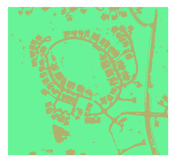
The merged DSM file within ArcMap should turn out pretty good if all your GCPs are tied down correctly. The final project will look something similar to figure 1. The map turns out a lot more accurate when compared to the basemap. There are some locations where the data on the maps is skewed. This would be in the south east corner of the map. This is the area of vegetation from the forest so this makes sense as to why the DSM file looks weird here.You notice the highest elevation within the map are areas to the northeast and the large piles of material through throughout the mapping area. The lake seems to be the area of lowest elevation which also makes sense. The GCPs allow us to easily connect separate flights into one data that overlay each other correctly. The Pix4D software seems to be very user friendly. It may be time consuming but easy to use. If you tie down the GCPs correctly you should run into little problems.

Figure 1

Monday, March 6, 2017

ArcGIS Pro Tutorial

Introduction

This lab will follow a tutorial from at arcGIS online here. The tutorial will teach us how to process UAS data and classify the surface images based on certain specifications

Methods

First click on the link and open the demo map provided in the tutorial. You will be directed to open the Calculate Surface imperviousness task.This will allow you to extract three bands to distinguish surfaces. They are displayed on the fly so no new dataset is created.
Follow the instruction 1-4 and click create new layer.
This will yield a map like figure 1
Figure 1
This creates an image that is easier to read. The vegetation shows up in the infared. This will make it easier to distinguish features in step two.

In this step we will segment the image.

First select Group Similar pixels into segments in the task bar.
Then complete steps 1-4 to create the new layer. This will create an image that looks like figure 2.
Figure 4
You will proceed to step 2 where you can review the segmentation before you move to the final step.This will complete lesson one.

Lesson 2
Open up the classify imagery task and open up arc map. In arcMap add both the Louisville Neighborhood and Segmented images. You will process classify this data in arcMap using the image classification toolbar. Next draw rectangles over a few houses in the north west corner.
Figure 3. Squares draw using image classification toolbar. 
Next select all of the class and merge them giving them the new class name grey roofs. You will do this with all the feature until you have a map that looks like figure 4. You can then save the classifications.
Figure 4
Next run the Train the Classifier task in ArcGISpro. And complete steps 1-5.


Next run the classify imagery tool following these steps yield a map like figure 5.

Figure 5
You will then run step two of the task to reclassify the data. This yields a map like figure 6.
Figure 6
In lesson 3 we will create Accuracy assessment points. You will use the create accuracy assessment points tool to get figure 7 with 100 accuracy points.
Figure 7
In the final project you will tabulate the area and clean up the attribute tables one the tables are joined. This will show you parcels of land that have the highest impervious surface. You will end with a map that looks like figure 8.
Figure 8
 Conclusion
This data produced a map that shows areas that have the highest area of impervious surfaces in darker colors. This happens to be areas of roads. This can help city planners determine storm water fees based on areas of lower impervious surfaces. If we have our own similarly accurate data we can go about the same process to classify the image using our own specifications.

Pix4D Processing Software

Introduction

Pix4D is an imagery processing software that is able to process data collected from various UAS systems. It is currently the best processing software for constructing point clouds. The program is able to process the data so it can be used in Geospatial programs like ArcMap. The program is easy to use and their online manual is easy to use. The processing part is time consuming but the speed can be adjusted dependent on the output quality required.

Preliminary Questions?
Look at Step 1 (before starting a project). What is the overlap needed for Pix4D to process imagery?
The recommended overlap is 75% frontal overlap (flying direction) and 60% side overlap (between flying tracks).
What if the user is flying over sand/snow, or uniform fields?
                Sand/Snow require a higher overlap of 85% frontal and 70% side overlaps. They also require the exposure to be set to get as much contrast as possible. Uniform fields require same overlap and that the UAS is flown at a higher altitude.
What is Rapid Check?
                It is an option for quickly processing data but in turn lose quality. It is a quick way to check data while in the field.
Can Pix4D process multiple flights? What does the pilot need to maintain if so?
                The program can process many flights if the flights were maintain at the same altitude.
Can Pix4D process oblique images? What type of data do you need if so?
                Yes as long the images have angles recorded for the data.
Are GCPs necessary for Pix4D? When are they highly recommended?
                You do not need to place GCPs but the lack of GCPs will create less accurate data. It is highly recommended to use GCPs to reduce the amount of possible vertical and horizontal inaccuracies.
What is the quality report?
                The quality report gives a summary of all the data processed. It will allow you to verify the accuracy of the data before you start to use it. It shows you how the data was processed and parameters to the data. It also can show you areas where the data needs to be fixed or recollected.

Methods
For this lab we were giving two sets of separate flight logs. We were then instructed to process this data in Pix4D. You first open up PIX4D and create a new project.

It is important to name the project accurately. Include the date, site, platform, sensor, and altitude. Then add all the image flies from one of the flight logs. We will do the second flight log separately. Here you can look at the data points and edit the camera settings so they are correct for your camera.


Then select process data with 3D maps.

 Then click ok. You will now do the initial processing. Make sure to uncheck point cloud and DSM options. This will slow down the whole process if not unchecked.


You can edit the processing options to choose speed and quality of the output data. Once the initial processing is completed it will give you a quality report.


The quality report is very useful because it will tell you the accuracy of the data and whether you should proceed to steps 2 and 3 of processing. Once steps 2 and 3 are completed you can turn of cameras and turn triangles on to view the map created from the processed data.


There are some areas where the overlap is poor. These are areas at the edge of the map where the UAS made fewer passes. The middle of the map the UAS goes back and forth creating plenty of overlap.
Video Animation of the Data
https://www.youtube.com/watch?v=4-CIyOPjLMs&feature=youtu.be

Conclusion

Litchfield Map 1
Figure 1 Litchfield Flight 1

Figure 2 Litchfield Flight 2
Conclusion
Figures 1 and 2 show the DSM data collected from the Phantom 3 processed with Pix4D. There is some distortion in the corners where there was lack of overlap.
Overall the program is easy to use. The data processing is time consuming but as long as the pilot collected good data, the processing yields great results. The data can then be imported to ArcMap to further be analyzed as in figures 1 and 2.   

Monday, February 20, 2017

Building Maps Using UAS Data


Introduction

Why are proper cartographic skills essential in working with UAS data?
                Without proper cartographic skills, UAS data will be useless. If you do not include things like north arrows or scale bars, the data will not make sense to the reader. The data needs to contain sources and your name so people know the creator of the map
What are the fundamentals of turning either a drawing or an aerial image into a map?
                This includes properly scaling and locating your map. A locator map will help orientate the reader. A north arrow and scale bar are also essential to produce a good map.
What can spatial patterns of data tell the reader about UAS data? Provide several examples.
                Spatial patterns can help a reader determine manmade objects from natural objects. They can help determine agricultural patterns and determining quality of the crop and how to improve the yield. You can use it geology to distinguish elevation changes and where potential geologic units are. You could use spatial patterns to determine deforestation rates in logging areas.
What are the objectives of the lab?
                The goal of the lab is to learn how to use UAS data to make cartographically correct maps in GIS. The map must be correctly labeled and scaled so the data makes sense. The lab will show us how to transfer the UAS data into Arcmap and how to correctly process it.

Methods

What is the difference between a DSM and DEM? What is the difference between georeferenced mosaic and an orthorectified mosaic?
                DSM (digital surface model) will show elevation for any surface feature located in the mapping area. This includes trees, vegetation, cars, people, roads, etc… DEM (digital elevation model) only shows the elevation of the ground feature and will not include trees or buildings. http://gis.stackexchange.com/questions/5701/what-is-the-difference-between-dem-dsm-and-dtm
                Georeferenced mosaics are more accurate then orthorectified mosaics. Georeferenced mosaics reference set ground control points. These GCPs have been placed accurately and are recorded. The orthorectified points from the UAS itself. These points have greater vertical and horizontal inaccuracies.
What are the statistics? Why use them?
                The statistics give you the maximum and minimum and average elevations which is useful because it will give perspective and a better reference.
How did you hillshade the DSM? Delineate regions of the DSM, thinking of each region in terms of topography, relating that to the vegetation.
                You need to search for the hillshade tool and make sure you have spatial analysis on. You then select the input raster and give a name and location for the output raster. You can also set the azimuth and altitude of the sun. You then let the tool process the data and get a map like this. You can delineate areas where there is a tree line running alongside the track.  

Results

What types of patterns do you notice on the orthomosaics.
                There is a distinct tree line on the west side of the track. You can clearly see the manmade features, road and track.
What patterns are noted on the DSM? How do these patterns align with the DSM descriptive statistics? How do the DSM patterns align with patterns with the orthomosaic?
                You can clearly see the elevation but can’t see the tree line as distinctly until you use the hillshade tool. The statistics allow you to tell the elevation range and give you a better perspective. Together they both give a good picture of the area. You can tell the elevation is increasing to the northeast so if you were running on the track heading north, you be moving up hill.
Describe the regions you created by combining differences in topography and vegetation.
                I created areas for vegetation where the tree line lies. I also created a north and south section to distinguish the difference in elevation.
Errors in Data
                The elevation said 22 meters and the elevation in Eau Claire is about 240 meters. There are also parts of the map that are cut off that could be useful data.
Best Data
                The best data seems to fall in the middle and the poor quality data seems to be at the edges where there are abrupt cut offs.

Conclusion
           
    UAS data is useful because you can take imagery quicker and more efficient with higher quality resolution dependent on sensors. The data can be easy to transfer over to GIS. UAS data also high accuracy when used correctly. If one use a UAS with many GCPS you can created a very accurate map. If the GCPs were not accurately set the data could be inaccurate. The user must know which sensors are being used and how the pilot collected the data to make sure it is accurate. A UAS is limited by weather and light conditions and on board sensors. A user could combine UAS data with survey data to make accurate maps. They could combine both the ground and aerial views.


Monday, February 6, 2017

UAS Platform Consulting

Introduction
            There are many different unmanned aerial systems on the market of varying cost and performance. This report will outline three separate drones of different performance levels. Their performance and cost will be discussed to make drone selection easier.
           

Low Level Commercial Drone: DJI Phantom 4
The Phantom 4 is DJI’s newest drone. DJI is a leader in quadcopter drones that are easy to fly and good for aerial photography. Their drones are perfect for beginner drone pilots. The Phantom 4 is also reasonably priced at around $1,200.
The Phantom 4 comes fully loaded with multiple features. The aircraft itself weighs less than 3 pounds and can fly 45 mph. The Phantom has a range of 3.3 miles and can operate at a max elevation of 19,000. The battery life has been improved from the earlier phantom drones and is suppose to last 28 minutes on a full charge.  The drone comes in a compact size of 13 inches across diagonally and can even be worn on a special backpack.
The Phantom has front and downward facing vision systems to help with collision avoidance.  This allows the drone to auto correct flight paths when the user is unaware of an obstacle. The vision system also is cable of actively tracking users.  The active track systems can track people or vehicles and follow them without user control.
The Phantom’s camera can shoot 4k videos at 30 fps and 1080 videos at 120 fps. This allows for superior video quality in the low-level commercial range of drones.  The camera has 12.4 M pixels and comes attached to a three-axis gimbal for steady footage.
Another great feature is the app to fly the Phantom. The app is user friendly and allows for live feed while flying. The app also works for both android and IOS.          The Phantom 4 is a great first buy drone. The drone takes superior quality video and the collision avoidance may increase the life of the drone. The drone comes at a fair price.


Mid Level Commercial Drone: xFold™ Dragon x8 RTF
            xFold makes professional drones that cater to cinematography producers. Their drones range in price from $4,000 to $27,000. The Dragon cost $25,000 with all the features included.
            The Dragon weighs 35 pounds but can carry up to 66 pounds in payload. It can carry large camera and video equipment. It can be dual operated, camera and pilot. The dual operation allows for better video production. The Dragon also has a live feed for the pilot with very little lag time. The drone is used in industrial and military applications as well.
            The dragon comes with two 22,000 mAh flight batteries increasing its range. The entire drone folds up and fits in a provided case. The drone is well balanced allowing it to fly in rough conditions. It comes with the highly compatible DJI NAZA V2 flight control system. There is also a smartphone app to assist in flight.
            The dragon has fail-safe system built in as well. If the drone flies out of range a backup system will activate, returning to home. The dragon can also fly if it loses a motor. The drone will change flight patterns and return to home.
            The dragon is relatively expensive but comes with a complete yearlong warranty. Its payload allows its uses to be very versatile. The drone also has technology that helps orientates the direction of flight, which can be hard with multirotar drones.


High Level Commercial Drone: Sensefly eBee Plus
            The eBee plus is a great high-end drone that cost around $20,000 to $30,000 dollars dependent on features. The drone it self is relatively the cheap but the software technology is where the money is.
            The eBee plus can fly for 59 minutes and can cover 15.4 mi2 in one flight. The drone is hand launched and can cruise at speeds of about 60 mph. The eBee comes with eMotion 3 flight planning and control software. It also comes with a Pix4DMapper image processing system.
            The High Precision on Demand technology reduces the need for ground control points and decreases the amount of time in the field.  Th eBee plus comes with different cameras to meet different needs.
            The motion 3 allows for detailed flight plans to meet very quickly. The Sensor Optimized For Drone Applications, returns superior quality geospatial data and photography.

            Sensefly drones have been field test around the world and used on numerous projects, from agriculture to disaster relief. There website is full of countless examples of professional and successful fieldwork. Dependent on the need the eBee plus seems to be a great option.